
The real science of Himalayan earthquakes ; why the Indian and Eurasian Plates create massive risks, why ‘overdue’ is a myth, and how mining, deforestation, and climate change are making things worse.
Here is something that should stop you mid-scroll: In November 2025, India quietly reclassified the entire Himalayan belt ; from Jammu & Kashmir to Arunachal Pradesh ; into a brand-new Zone VI, the highest earthquake danger category ever used in the country’s history. That means the mountains you call home, or visit for trekking, or see on your phone screensaver, sit directly above one of the most violent geological forces on Earth.
And scientists say a magnitude 8.8+ earthquake is not just possible ; it may already be long overdue. But here’s the twist: the Earth doesn’t care about your calendar.
The Himalayas are not just a pretty backdrop for Instagram reels. They are the scar left by a 50-million-year-old collision ; and that collision is still happening, right now, beneath your feet. Let’s break down what that actually means.
The World’s Slowest Crash And Its Deadly Consequences
Imagine two enormous trucks, each the size of a continent, driving straight at each other at roughly 5 centimetres per year. That’s slower than your fingernails grow. But they’ve been at it for 50 million years ; and the wreckage is the highest mountain range on Earth.
The Indian Plate is pushing north into the Eurasian Plate. This ongoing crash created the Himalayas, keeps pushing them higher every year, and builds up enormous amounts of stress along giant cracks in the Earth called fault lines. The most important of these is the Main Himalayan Thrust (MHT) ; a massive underground fault running beneath the entire mountain range.
Think of it like pressing your palms together. The harder you push, the more pressure builds between them. Now imagine you’ve been pressing for 50 million years. At some point, your hands are going to slip ; and when they do, the shockwave is catastrophic.
The Himalayas are the only place on land where magnitude 8+ ‘mega-earthquakes’ can occur. The Indian Plate adds 5 cm of new stress every single year.
What Happens Underground
The Indian Plate doesn’t slide smoothly under the Eurasian Plate. Instead, the two plates “lock” together in many places. They freeze. The energy keeps building. And then, suddenly ; like a coiled spring snapping ; the locked section breaks loose and releases all that stored energy at once. The result is a powerful earthquake.
Scientists at Caltech and ISRO have identified four specific segments of the 2,000-kilometre Himalayan arc that are currently locked and building dangerous amounts of stress. Researchers estimate that these segments could produce earthquakes of magnitude 8.5 or higher ; powerful enough to flatten cities.
For more on how this process works, watch this excellent animation from IRIS
The Silent Zones That Scare Scientists the Most
Not every part of the Himalayan fault has broken recently. Some sections have not ruptured in over 200 years. These areas ; where stress keeps accumulating but the fault hasn’t snapped ; are called “seismic gaps.”
The central Himalayas, covering parts of western Nepal, Uttarakhand, and Himachal Pradesh, contain a particularly worrying seismic gap. Between mid-December 2024 and January 2025 alone, ten earthquakes of magnitude 4.0 or greater rattled western Nepal. Seismologists say this swarm of smaller quakes could be a warning sign ; a region trying to release pressure before a much bigger event.
“This region is prone to earthquakes any time due to accumulated stress. It is not a matter of if ; it is a matter of when.” ; Dr. N. Purnachandra Rao, National Geophysical Research Institute (NGRI), India
Between November 2024 and February 2025 alone, India recorded 159 earthquakes of various sizes. Officials have stepped up preparedness campaigns ; but the seismic clock keeps ticking.
India’s New Zone VI
In a landmark move in November 2025, India released a revised seismic hazard map under the updated Earthquake Design Code. For the first time, the entire Himalayan belt was unified into Zone VI ; the most dangerous seismic category in Indian history.
What does this mean practically?
- All new buildings in the Himalayan belt must now follow far stricter earthquake-resistant design codes.
- Hospitals, schools, and bridges must be built to remain functional even after a major earthquake.
- Areas once considered moderate risk are now classified as high or extreme risk.
- An estimated 61% of India’s landmass now falls under moderate to high seismic hazard zones ; up from 59%.
Two Earthquakes That Changed Everything
January 15, 1934 ; The Day Bihar Disappeared
On a cold January afternoon in 1934, the ground beneath Bihar and Nepal split open without any warning. At 2:13 PM, an earthquake measuring magnitude 8.0 struck with its epicentre just 9.5 kilometres south of Mount Everest. What followed was one of the worst disasters in South Asian history.
Over 15,700 people were killed ; 8,500 in Nepal and 7,200 in India. The towns of Munger and Muzaffarpur were completely destroyed. In Kathmandu, three historic cities ; Kathmandu, Bhaktapur, and Patan ; were severely damaged. Sand geysers erupted from the ground. Rivers changed their courses. The Kosi Rail Bridge washed away.
The earthquake was so powerful that it was felt from Lhasa in Tibet all the way to Bombay (now Mumbai) ; a distance of over 2,000 kilometres. The iconic Navlakha Palace in Bihar was left in ruins. Mahatma Gandhi visited the region; Rabindranath Tagore wrote about the disaster.
Today, with population density having multiplied several times over, scientists estimate that if the same earthquake happened again, it could kill over 50,000 people in India alone.
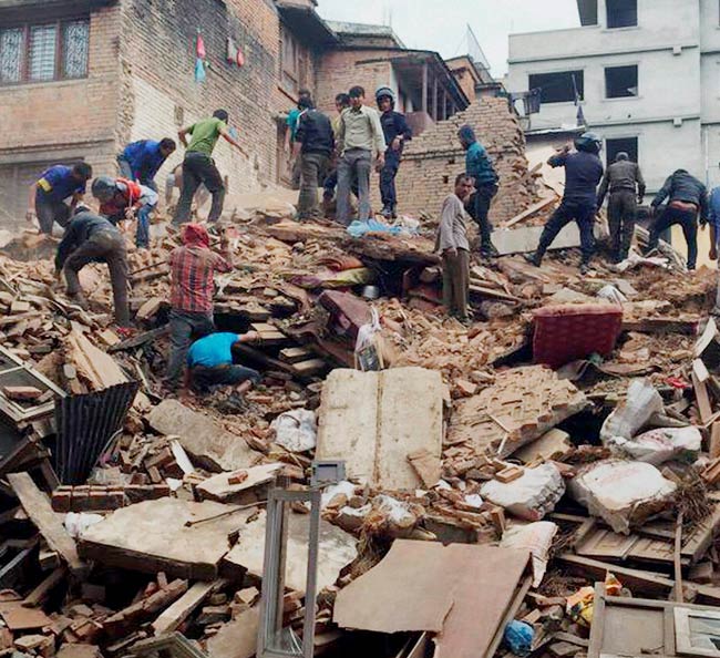
April 25, 2015 ; The World Watches Nepal Fall
Eighty-one years later, the fault struck again. On a Saturday morning in April 2015 ; when markets were full and children were playing outside ; a magnitude 7.8 earthquake tore through central Nepal.
Over 9,000 people died and 23,000 were injured. More than 500,000 homes were destroyed. The Dharhara Tower, an iconic Kathmandu landmark rebuilt after the 1934 earthquake, was reduced to rubble again. UNESCO World Heritage sites crumbled. An avalanche at Mount Everest Base Camp killed 17 more.
The 2015 Gorkha earthquake also triggered over 4,000 landslides, blocking roads and delaying rescue efforts for days. It was a brutal reminder that in the Himalayas, an earthquake is never just an earthquake ; it starts a chain reaction.
Watch a documentary on the 2015 Nepal Earthquake
“Earthquakes are unavoidable, but we can minimize their impact by constructing earthquake-resistant structures and enhancing preparedness.” ; Nepali Prime Minister K.P. Sharma Oli, National Earthquake Safety Day, January 2025
Why “Overdue” Is the Most Dangerous Word in Geology
Every few months, a headline screams: “The Himalayan Earthquake Is Overdue!” It sounds terrifying. But scientists will tell you the word “overdue” is actually misleading ; and understanding why is crucial.
Earthquakes don’t work like buses. There’s no timetable. The Earth doesn’t reset a clock after every earthquake and start counting down to the next one. What scientists can measure is stress accumulation ; how much energy has been stored in a locked fault segment ; and estimate the range of possible future events.
The Earth doesn’t know it’s ‘overdue.’ The stress doesn’t care about your calendar. What matters is preparation ; right now, not after the next big one.
The central Himalayas have not had a major surface-rupturing earthquake in almost 200 years. That’s a long time for stress to build. ISRO and NASA-led research, published in the journal Geophysical Research Letters, found that tectonic stress in the mid-Himalayan region was significantly higher than previously measured ; enough for potential earthquakes reaching magnitude 8.8.
But that doesn’t mean the earthquake will happen tomorrow. Or next year. Or in ten years. It might. Or it might not happen for another century. Geological time doesn’t obey human schedules.
What Is a ‘Seismic Gap’ and Why Should You Care?
A seismic gap is a stretch of fault that hasn’t snapped in a very long time ; while the plates on either side keep moving. The longer the gap, the more stress has accumulated. Some gaps are hundreds of kilometres long and centuries old.
Scientists from Caltech, using GPS satellite measurements, have identified four such high-locking, high-risk segments along the 2,000-km Himalayan arc. These regions, located in parts of India, Nepal, and Bhutan, are the most likely sources of the next great Himalayan earthquake.
Understanding seismic gaps helps engineers decide where to build stronger structures, where to place early-warning systems, and where to focus disaster preparedness drills. It’s not about predicting doom ; it’s about building smarter.
We’re Making It Worse ; Mining, Construction, Deforestation, and Climate Change
Here’s where the story takes a darker turn. While tectonic forces are natural and unstoppable, human activity is making Himalayan disasters significantly more deadly. We are, in a very real sense, turning natural hazards into catastrophes.
Mining and Blasting ; Shaking an Already Shaking Mountain
Large-scale quarrying and mining operations in the Himalayan foothills involve constant blasting and excavation. This weakens rock formations, destabilises slopes, and can trigger localised tremors that add to existing tectonic stress. In a region already primed for earthquakes, every additional blast is a risk.
Unplanned Construction ; Building Coffins Instead of Homes
The Himalayas are among the world’s most rapidly urbanising mountain ecosystems. Millions of people are moving into seismically active zones and building structures without earthquake-resistant features. In 2015, the vast majority of homes destroyed in Nepal were built with unreinforced stone or brick masonry ; essentially death traps during strong ground shaking.
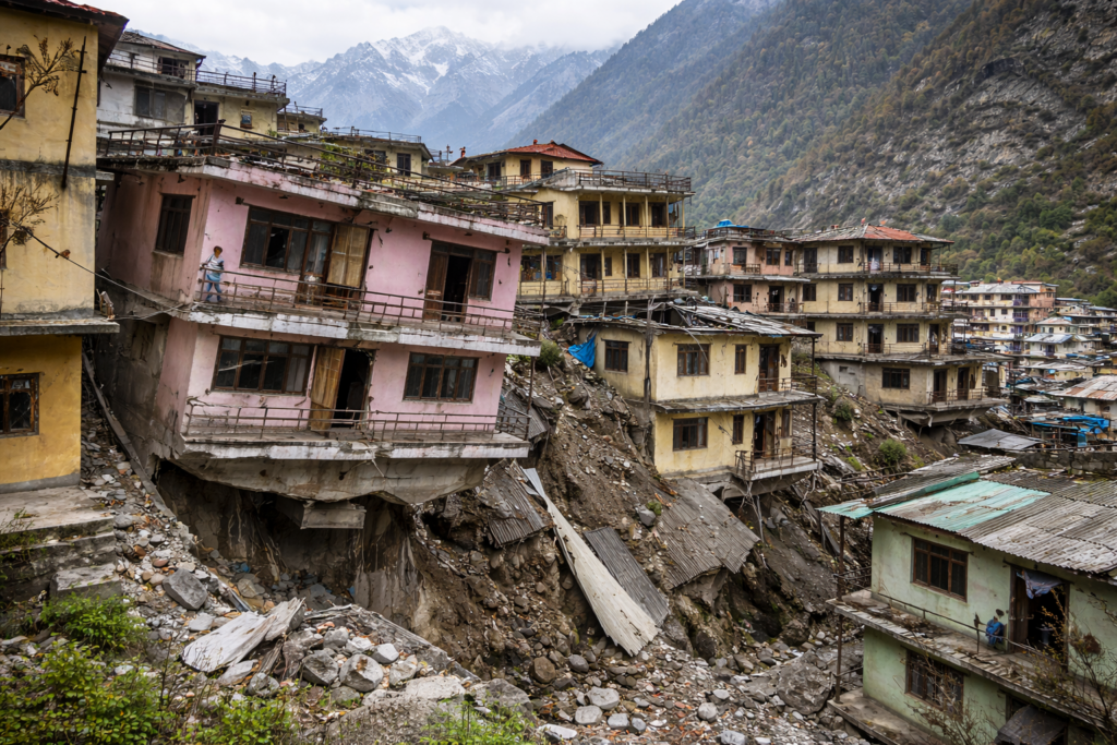
The Joshimath land subsidence crisis of 2023 was a stark warning: when you build on unstable Himalayan geology without proper engineering, the ground literally sinks beneath you.
Deforestation ; Removing Nature’s Safety Net
Forests in the Himalayas play a critical role in holding soil together on steep slopes. When trees are cut for agriculture, construction, or firewood, the soil loses its binding power. During an earthquake, those same bare slopes become rivers of rock and mud ; triggering landslides that kill far more people than the initial shaking.
Research shows that anthropogenic activities account for nearly 50% of all landslides in the Lesser Himalayas. Road construction alone has doubled the rate of slope failures during extreme rainfall events.
Climate Change ; Pouring Fuel on the Fire
Climate change is melting Himalayan glaciers at alarming rates. As ice disappears, it exposes unstable slopes. Glacial Lake Outburst Floods (GLOFs) become more common. An earthquake that might once have triggered a minor landslide can now trigger a catastrophic flood if a glacial lake is disturbed.
More intense monsoon rains ; driven by a warming climate ; are also saturating soil faster, making earthquake-triggered landslides far more dangerous than they were a century ago.
Climate change doesn’t cause earthquakes ; but it multiplies their death toll. A warming planet means a deadlier earthquake when it finally strikes the Himalayas.
What Can We Actually Do?
The good news ; and yes, there is good news ; is that earthquakes are survivable. Buildings built to earthquake-resistant standards perform dramatically better. Communities that run drills lose far fewer lives. The knowledge exists. The question is whether we act on it.
For Individuals and Families
- Learn the Drop, Cover, Hold On technique ; practice it with your family.
- Identify the safe spots in your home away from windows and heavy objects.
- Keep a 72-hour emergency kit: water, food, first-aid, torch, and copies of important documents.
- Know your building’s construction type ; is it earthquake-resistant?
- Follow local disaster management advisories during periods of seismic activity.
For Governments and Builders
- Strictly enforce the new Zone VI building codes released in November 2025.
- Retrofit old buildings ; especially schools, hospitals, and government offices.
- Ban construction on active fault lines and soft sediment zones.
- Invest in early-warning sensor networks across the Himalayan belt.
- Stop issuing mining and quarrying permits on seismically sensitive slopes.
A Word from Our Founder
Nikhil Raj Sharma | Founder, Himalayan Geographic Research Foundation
“I have walked the ridges of Uttarakhand and watched the mountains breathe ; not metaphorically, but literally. You can see cracks in old walls that appear overnight, streams that change course after small tremors, and boulders that have moved without anyone seeing them move. The Himalayas are alive in every sense of the word. What concerns me most is not the earthquake itself ; nature does what nature does. What concerns me is our arrogance: we build hotels on fault lines, blast roads through seismic zones, and cut down the very forests that hold these mountains together. We have forgotten that we are guests here.”
“At Himalayan Geographic, we believe that awareness is the first form of preparedness. You cannot prepare for what you don’t understand. This article is not meant to frighten you ; it is meant to wake you up. Share it with your family. Show it to your local councillor. Demand earthquake-safe schools for your children. Because the mountain will shake again. The only question is whether we are ready.”
Related Articles & Resources
- India’s Revised Seismic Map ; What Zone VI Means
- Himalayan Earthquake Warning 2025 ; NewsZenith
- Geodetic Data Pinpoints Earthquake-Prone Himalayan Zones ; EOS
- 1934 Bihar–Nepal Earthquake ; Detailed History:
- IRIS Himalayan Earthquake Animation (YouTube)
- Nepal Earthquake 2015 Documentary
Disclaimer: The content and images published in this article are provided for general informational and educational purposes only. Some images may be generated or enhanced using artificial intelligence (AI) and are intended solely for illustrative use. The views, interpretations, and information expressed do not necessarily reflect the official position of Himalayan Geographic Research Foundation, nor do they constitute professional, legal, medical, or financial advice.
While efforts are made to ensure accuracy, no guarantees are given regarding completeness or reliability. Readers are encouraged to independently verify information and use their own judgment. By reading this article, you acknowledge that any reliance on the content is at your own risk, and Himalayan Geographic Research Foundation assumes no responsibility or liability for disagreements, interpretations, or outcomes arising from its use. If you do not agree with these terms, you are advised to discontinue reading.
